
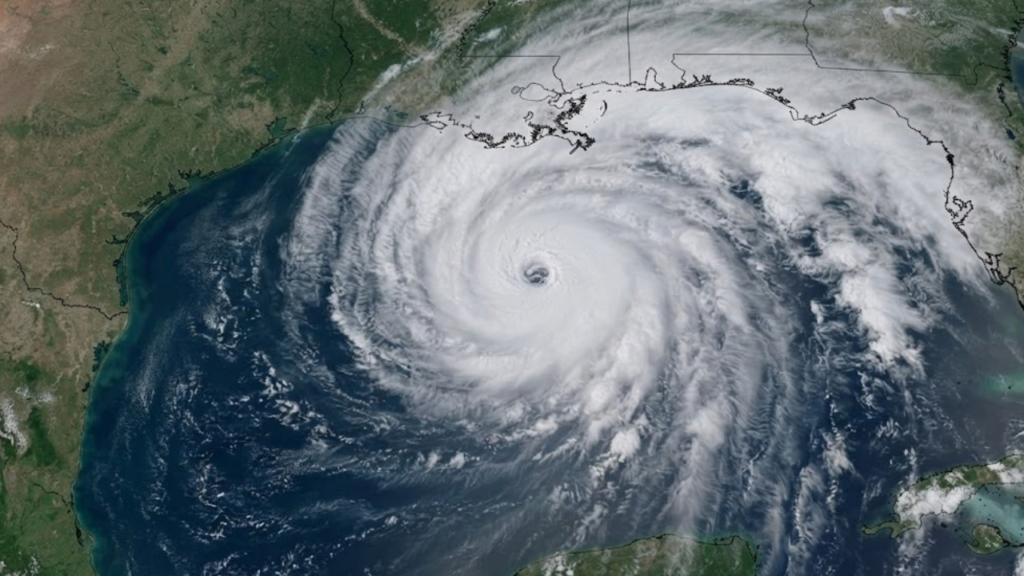
Hurricane Isaias Gulf Coast evacuations widened on Friday as officials in Florida and Alabama sent visitors away from beaches, closed schools and airports, and prepared shelters ahead of a landfall expected this weekend. The storm is the first hurricane of the Atlantic season. It strengthened into a Category 2 hurricane on Thursday and was moving toward the northern Gulf Coast.
CNN reported early Friday that Isaias was expected to become a major hurricane soon, meaning Category 3 or stronger. The Red Cross expects landfall late Friday or early Saturday. Forecasters have warned of life-threatening storm surge, tornadoes and flooding.
Hurricane Isaias Gulf Coast evacuations: where orders are in force
In Florida, mandatory evacuations took effect at noon local time on Thursday for coastal Zones A and B of Okaloosa County. The order covers Okaloosa Island and parts of Destin, Fort Walton Beach, Mary Esther and Niceville. Officials had also asked out-of-town visitors to leave the forecast impact area. The county announced plans to close three airports, and local government offices shut down as the storm approached.
Gov. Ron DeSantis declared a state of emergency in 25 counties. He said about 5,000 National Guard troops were expected to mobilise by Friday and urged residents to take the storm seriously. At least four Florida school districts cancelled classes for later in the week.
In Escambia County, which includes Pensacola Beach, residents and visitors were told to evacuate if ordered or to prepare to shelter. Pensacola’s mayor asked people to prepare for bridge closures. Local officials have warned that a possible nighttime landfall, combined with storm surge and a tornado risk, makes the situation especially hazardous.
Alabama has taken similar steps. Gov. Kay Ivey ordered non-residents to leave Gulf Shores, Orange Beach and Dauphin Island immediately. Her state of emergency covers 40 counties. Baldwin County encouraged residents of low-lying coastal areas to evacuate voluntarily and prepared emergency shelters. Traffic was reported at a standstill on the highway leading out of Gulf Shores, where double red flags signalled that the water was closed.
How residents are preparing
Across the Alabama and Florida coast, people boarded up windows, filled sandbags and stocked up on fuel, groceries and water. Cities including Orange Beach handed out sandbags to residents, and in Gulf Breeze, Florida, families loaded sandbags to guard against possible flooding. Fishing crews secured their boats, and vehicles lined up to leave Perdido Key.
Some people plan to stay. In Loxley, Alabama, a couple intended to ride out the storm on their farm, which is home to dozens of animals. County officials there had urged voluntary evacuations For readers following other developing stories on HCN, our earlier report on the Papatoetoe deaths police investigation is available on the site.
Shelters and emergency response
The Red Cross said it was working with state and local officials to identify shelters from Louisiana to Florida. It said the shelters across Florida, Louisiana, Alabama and Mississippi could house several thousand people. More than 370 trained disaster workers were supporting the response, many of them local responders, and shelter supplies and shelf-stable meals had been moved into position in Georgia.
Oil production and tourism hit before landfall
The storm has already affected the Gulf’s energy industry. As of Wednesday, about 25% of regional oil production had been halted, removing roughly 511,000 barrels a day from the market. Eight of the Gulf’s 371 manned platforms had been evacuated, according to a federal agency cited by the Associated Press. These figures are from before the storm strengthened, so the current numbers may be higher. Tourism has also been disrupted. Beach visitors were ordered out of popular Alabama destinations, and some Florida local government offices closed.
What remains uncertain
Forecasts for the storm’s strength near landfall differ. Reuters reported that forecasters expected winds of about 110 mph (175 km/h) early Friday, followed by some weakening because of increasing wind shear near the coast. They stressed that the storm would remain dangerous. Other outlets expect a stronger hurricane. The exact landfall location and timing could still change.
No deaths or damage had been reported at the time of writing. For the latest official track, warnings and advisories, readers should check the National Hurricane Center.